Locating Solomon's Temple
NEHEMIAH WALL
The old wall of Jerusalem
The old wall of Jerusalem
Chapter Two
Nehemiah's wall gives us some important information that helps identify where the Temple was NOT located. According to scripture Nehemiah did not rebuild any of the Temple walls. He only rebuilt the City walls, which means that the lower courses of stones in the east wall of the Mount were part of that city wall that Nehemiah rebuilt. The ruins of the oldest gate in the eastern wall still remain beneath the Muslim East Gate that we see today. It was NOT the east gate of Solomon's Temple.


Even though I agree with Dr Ritmeyer about Hezekiah's wall beginning with these two stones, I disagree that it was a wall of the Temple. Remember Nehemiah rebuilt the city wall only. He did not rebuild any of the outer walls of the Temple. Leen Ritmeyer claims this old Hezekiah city wall was the east wall of the Temple compound and so places the location of the Temple where the Dome of the Rock now stands.
Notice in the diagram that the Muslim gate is in the uppermost northern position in Hezekiah's wall. Also the Hasmonean (165 BC) (in yellow) claimed more of the steep east hill by extending the old wall further toward the south.
North Wall and Fort Antonia
It is interesting to trace the changes in the area from the time that Nehemiah rebuilt the city wall, all the way up to when Josephus describes Fort Antonia. The wall described by Nehemiah had two towers on it's north wall, the Towers Meah and Hananeel. These towers protected the Temple from a northern attack.
 Walls at the time of Nehemiah in red Black dashed lines indicate the walls of the Mount as they are today Click on pictures to enlarge
The Meah fortress was built upon under the Hasmonean, during the late 2nd century BC,
and was renamed the Tower Baris. It was rectangular and possessed several high towers.
The Baris was connected to the Temple by an underground passageway. The Baris was then besieged by Pompey the Great in 63 BC.
Under Herod the Great, the Baris underwent extensive reconstruction, and he named it Fort Antonia in honor of Mark Anthony. Fort Antonia, just as the Baris and the Meah before it, was located on the old north wall that Nehemiah rebuilt. It overlooked a moat on its north side.
The Moatand was renamed the Tower Baris. It was rectangular and possessed several high towers.
The Baris was connected to the Temple by an underground passageway. The Baris was then besieged by Pompey the Great in 63 BC.
Under Herod the Great, the Baris underwent extensive reconstruction, and he named it Fort Antonia in honor of Mark Anthony. Fort Antonia, just as the Baris and the Meah before it, was located on the old north wall that Nehemiah rebuilt. It overlooked a moat on its north side.

According to Josephus this moat separated Fort Antonia from the hill to its north.

It is my belief that the walls of Fort Antonia were at a Northwest angle to the Temple. There is a step at the northwest corner of the Dome of the Rock platform. The bottom step is not a step at all. It is in fact a very old wall set at an angle. The red line in the map shows the old west wall following that same angle as it bends southward, forming the old northwest corner of Fort Antonia. Since the discovery of this wall the Muslims have covered it up but it was well documented beforehand.
Recently coins from the 1st century were found under the west wall of the Temple Mount that we see today. This means that Herod the Great did not build the southern portion of the west wall, including the bridge called Robinson's Arch. However this bridge was one of the west gates Josephus claimed entered directly into the 600 x 600 foot Temple complex. We also know that the walls were not completed until 66 AD and yet Josephus seems to attribute it all to Herod the Great, who died in 4 BC, so this work was most likely completed under Herod Agrippa I and Herod Agrippa II, of the "House of Herod".
Below would have been Fort Antonia and the Temple in the first century, after the work extending the temple courts was complete.

Red arrows show six furlong around (Furlong =600 ft)
Josephus describes Antonia as a tower (fortress) with four towers and around it were other towers. In other words a fortress/citadel within a fortress. Two colonnades on the west and on the north connected Fort Antonia to the Temple. According to Josephus the Temple and Fort Antonia, together, were six furlong around. (War of Jews Book 5, 5) Meaning the Temple and Fort Antonia were each 600 x 600 feet. This tells us that Fort Antonia only took up a small portion of the Temple mount we see today.
City walls during the first century

Herod rebuilt this wall and also built a wall around the north quarter of the city (in green).
A third city wall included the city of Bezetha (purple). This third wall connected to the old Hezekiah city wall on the east. There wasn't a wall between Bezetha hill and the moat.
May 4, 2014 -The above map has been recently updated because of this descrption by Josephus
War of the Jews Book 5. 4. 2
.......The second wall took its beginning from that gate which they called "Gennath," which belonged to the first wall; it only encompassed the northern quarter of the city, and reached as far as the tower Antonia.
The beginning of the third wall was at the tower Hippicus,............It was Agrippa who encompassed the parts added to the old city with this wall, which had been all naked before; for as the city grew more populous, it gradually crept beyond its old limits, and those parts of it that stood northward of the temple, and joined that hill to the city, made it considerably larger, and occasioned that hill, which is in number the fourth, and is called "Bezetha," to be inhabited also.
Previous Chapter
Return to Table of Content
Locating Solomon's Temple
TEMPLE GATES
Chapter Three
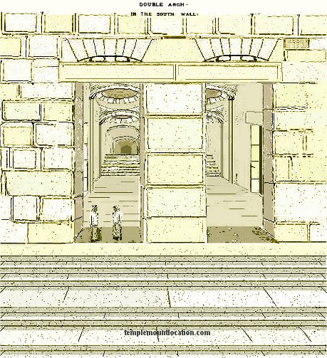
The gates of the Temple were very large buildings. People entered in through the right archway and exited through the left archway.
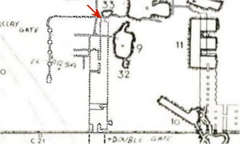
There were two gates in Herod’s northern wall: the North gate and the Tadi gate, which was used by priests if they had become impure. The gate's special lintel was built from two stones, one leaning on the other, together forming a triangle. Warren’s description of cistern #6 is that its shape inside was like a hollow truncated pyramid.
These two underground cisterns, numbers 36 and 6 on Warren’s map, seem to be part of the ruins of Herod's North gate and the Tadi gate.
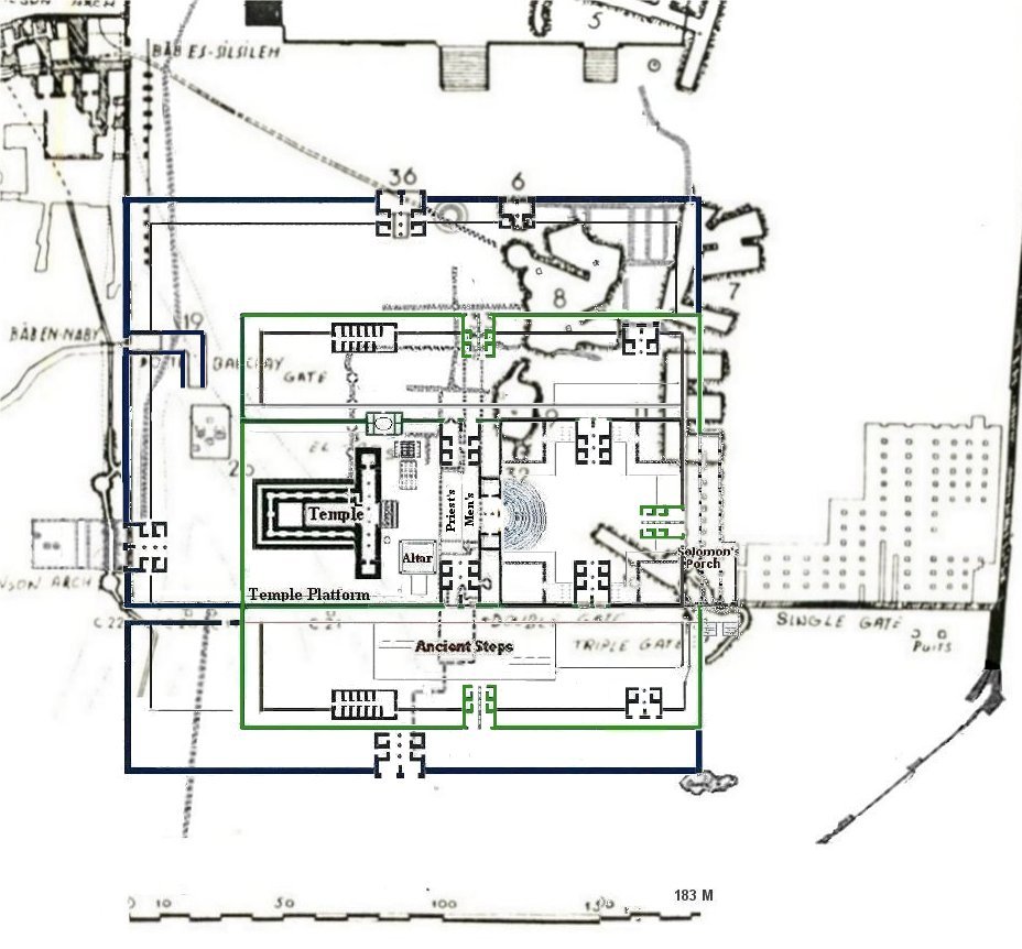
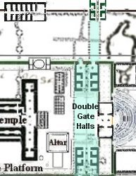
Six hundred feet straight across from Robinson’s Arch is the underground halls called Triple Gate on Warren’s map. Inside Triple Gate on its western side, part way up the passageway, was what appeared to be a huge lintel of a gate. This gate would have been the true East Gate to the Temple.
The same gate can also be seen on Sir Charles Wilson’s map (red arrow). This map shows what is both above ground and below the surface.

Triple Gate There are three archways of what are called Triple Gate in the South wall of the Temple Mount.
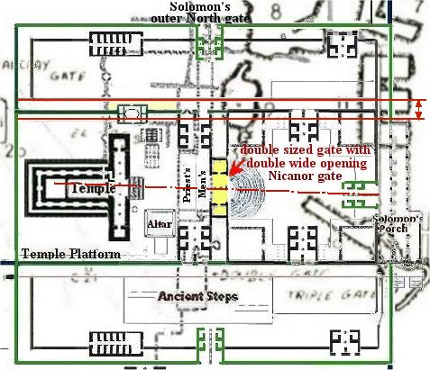
This would make the inside hall on the left (west) Solomon’s Stoa, which lined the eastern wall inside the Temple complex. The other two, on the right (east), entered an arched entryway, a porch, so to speak, to the east gate. The Kings entrance, because Solomon had built his palace just south of this on the Ophel Mound and he entered through the East Gate into the temple complex.
When entering the two arches on the right the East Gate would have been on the western wall of the portico and entered directly into the Women's Court.
At the time this picture was taken these halls were full of tons and tons of dirt and debris, leaving only the tops of the arches exposed. These halls do not lead up to the Mount surface, and never did.
Solomon’s Portico
To think that Solomon’s Porch might still exist to this day, buried beneath the surface of the Temple Mount, is amazing to say the least.
“Attached to the original temple of Solomon was the porch of judgment where king Solomon had constructed a large hall 50 cubits long and 30 cubits wide. The "porch" or "portico" was located on the east side of the outer court of the New Testament Temple of Herod.”
“Attached to the original temple of Solomon was the porch of judgment where king Solomon had constructed a large hall 50 cubits long and 30 cubits wide. The "porch" or "portico" was located on the east side of the outer court of the New Testament Temple of Herod.”
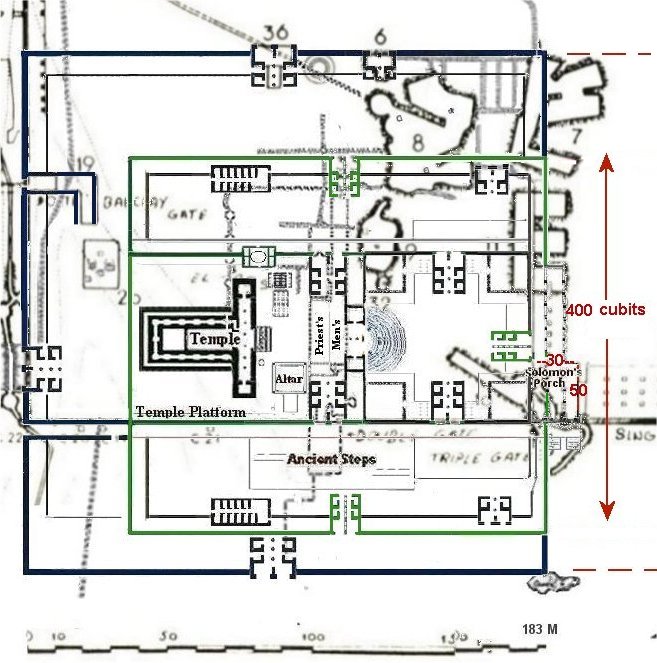
The lower section of the Triple Gate halls on Warren's map, is a three-aisled portico, and is approximately
50 x 30 Hebrew cubits and the woman's court was the outer court of the Temple. So this fits the description rather well.
50 x 30 Hebrew cubits and the woman's court was the outer court of the Temple. So this fits the description rather well.
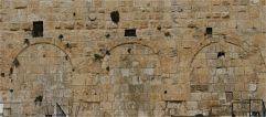
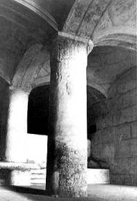
Double Gate Double Gate is also located in the south wall of the Mount. Only a small portion of one of these arches can be seen today. They were covered up when the Crusaders built a building against the South Wall.

This is an illustration of Double Gate after being rebuilt sometime after the Temple of Jupiter was torn down in 325 CE.
We know this because of a plaque, of a statue that stood before the Temple of Jupiter, was built into the wall upside down on the right side of the east arch. However, many of the wall stones are Herod stones, such as the center divider between the two gates and the lower courses of the wall itself.
We know this because of a plaque, of a statue that stood before the Temple of Jupiter, was built into the wall upside down on the right side of the east arch. However, many of the wall stones are Herod stones, such as the center divider between the two gates and the lower courses of the wall itself.

This is how the double gate halls appears on Warren’s map (In blue)
Below is the same map with an overlay of my diagram
I believe these halls to be where the old inner gates were once located. The inner south and north gates with the Men's court in between.
The double halls lay deep below Al Aksa Mosque. I don't believe these halls to have been built by Herod. They are built with recycled stones and columns. In fact they were built after the 70 CE destruction of the Temple. Even though these great halls were built after 70 CE, they were built upon those things that remained from second temple era, such as the huge stones of the eastern and western doorposts on the entrance to the Double Gate which belong to the remaining course of stones in the southern wall of the Temple. The existence of the original floor level and the remains of the original gate foundations. The same is true of the intermediate gate pier, built of huge ashlars with drafted margins, and of the two monolithic lintels with their drafted margins posed above the two doorways-the eastern lintel cracked at a later stage. Based on the archaeological evidence, the Herodian foundations of the side walls are visible, but only on the lower courses of the eastern wall, where they consist of large stones in the typical Herodian boss technique exploiting a considerable portion of the ancient masonry found in situ.
Charles Warren wrote:
"Double Passage " is a tunnel built through the made earth of the Haram... at one time the passage only extended for 190 feet from the south wall of the enclosure.... When the Aksa was built, it appears that the passage was extended to its present length (260 feet) ,but on the east side only”
This means the Halls did not lead up to the Temple Platform when they first were built but one passage was extended after the Mosque was built. It is possible that a group of people dug out the inner gates and the men’s court to preserve the area, perhaps to create a place of Jewish prayer sometime after 325 CE.
Perhaps the builders of these halls could have been the Jews that were allowed to return to rebuild their Temple in 360 - 363 CE. The work stopped when an earthquake hit and fire issued out of the ground. Many people were killed or maimed.
The Muslim’s claim that these halls were part of the first wooden mosque built on the mount that collapsed during an earthquake. But these halls are made of stone not made of wood, as was the old mosque.The double halls lay deep below Al Aksa Mosque. I don't believe these halls to have been built by Herod. They are built with recycled stones and columns. In fact they were built after the 70 CE destruction of the Temple. Even though these great halls were built after 70 CE, they were built upon those things that remained from second temple era, such as the huge stones of the eastern and western doorposts on the entrance to the Double Gate which belong to the remaining course of stones in the southern wall of the Temple. The existence of the original floor level and the remains of the original gate foundations. The same is true of the intermediate gate pier, built of huge ashlars with drafted margins, and of the two monolithic lintels with their drafted margins posed above the two doorways-the eastern lintel cracked at a later stage. Based on the archaeological evidence, the Herodian foundations of the side walls are visible, but only on the lower courses of the eastern wall, where they consist of large stones in the typical Herodian boss technique exploiting a considerable portion of the ancient masonry found in situ.
Charles Warren wrote:
"Double Passage " is a tunnel built through the made earth of the Haram... at one time the passage only extended for 190 feet from the south wall of the enclosure.... When the Aksa was built, it appears that the passage was extended to its present length (260 feet) ,but on the east side only”
This means the Halls did not lead up to the Temple Platform when they first were built but one passage was extended after the Mosque was built. It is possible that a group of people dug out the inner gates and the men’s court to preserve the area, perhaps to create a place of Jewish prayer sometime after 325 CE.
Perhaps the builders of these halls could have been the Jews that were allowed to return to rebuild their Temple in 360 - 363 CE. The work stopped when an earthquake hit and fire issued out of the ground. Many people were killed or maimed.

This sketch was drawn of the double gate halls as it might have looked when first built.
Below is a sketch of what Warren actually saw

Below is a photo taken in 1902


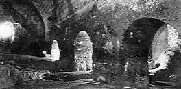
The mishna. Para 3.3 tells us that "The Temple Mount and the Temple Courts had a hollow space beneath them in case there was a grave in the depths".
“From the inner court the Priests entered the hollow by lifting a marble slab.
In the North (inner) gate near the threshold there was a black slate slab that was also an entrance to these hollows”.
So not only do we find that there is a Jewish Mikveh below the Al Aqsa Mosque but also the required hollows that would have been cut into the rock below the Temple courts!
Summary
This is a good time to review the physical evidence supporting my theory.
- Nehemiah did not rebuild the walls of the Temple complex. He only rebuilt the city walls. This means the east wall of the Mount we see today was never a part of the Solomon’s Temple walls. Remember Solomon's temple and Herod's Temple shared the same east wall and gate.
- There is a 600 x 600 foot square on the mount/ophel that has evidence of four gates in the right position to have been the gates of Herod’s Temple.
- The water aqueduct enters the Mount and veers to the south for a southern placement of the Temple, rather than towards the north for a Dome of the Rock location.
- The water system has a pool at the end of a branch, which is located next to the temple, according to my design, for filling the Brazen Laver.
- Another branch of the water system ends at the Priests court, according to my design, which would allow for the cleansing of the court each day.
- The Double Gate arch in the south wall of the Mount is located in the same place where the South Inner Gate to the upper courts would have been located according to this design.
- Triple gate is in the right position to have once been Solomon’s Portico
Locating Solomon's Temple
THE SOUTHEAST CORNER
Chapter Four

Moving on to the southeast corner known as the section containing Solomon's Stables. What an imposing site the southeast corner is. Trying to visualize the mount without this corner in the time of Herod is difficult, but that may have been the case. The upper portion of the wall, all the way around the mount, was built by the Muslims after 638 CE. Below that, is a portion that was constructed by the Romans and Bezintines.

So the question is, did Herod’s descendants build the wall from the Hasmonean wall all the way around to Triple Gate on the south wall, or was it built at a later time?


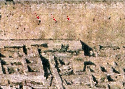
In November 1868, Captain Charles Warren of the British Royal Engineers dug a vertical shaft around 90 feet down to the bedrock at the SE Angle of the Temple Mount Platform. This sketch shows what they found.

This wall is made up of recycled Herod/Herodian stones taken from somewhere else and used to build this wall. Some of the stones even have mason marks on them. The masons cut and marked the stones at the quarry so that the builders could place them properly to create the specified building, much like a prefab house today.
This is a quote from the PALESTINE EXPLORATION FUND. Patron— THE QUEEN. Quarterly Statement. JANUARY 1869— SEPTEMBER 1870.
“34 LETTER OF MR. EMANUEL DEUTSCH. I must now speak somewhat fully on a subject which has engaged public attention for some time, and has already given rise to many conjectures — namely, the " Writings," either painted on, or cut into, the stones, discovered lately on the bottom rows of the wall at the south-east corner of the Haram, at a depth of about 90 ft, there where the foundations lie on the live rock itself.” -end quote (Note: He believed them to be based on Phoenician letters)
This section of the east wall was not built by Herodian builders.
Compare the sketch to the photo taken of the Southwestern corner, a wall proven to have been constructed by Herodian builders. See how the marginal dressing in the photo is the same on every stone, unlike the mismatched stones in the sketch of the southeast corner.

Who Built the Southeast Corner and Why?
This section of the east wall was most likely built by the Roman Emperor, Hadrian, around 130-35 AD. He needed an enlarged, flat, mount to build the Temple of Jupiter complex on.
Here is an example of the Temple of Jupiter complex in Lebanon, just to get an idea of its size and shape.
 Temple of Jupiter-Lebanon
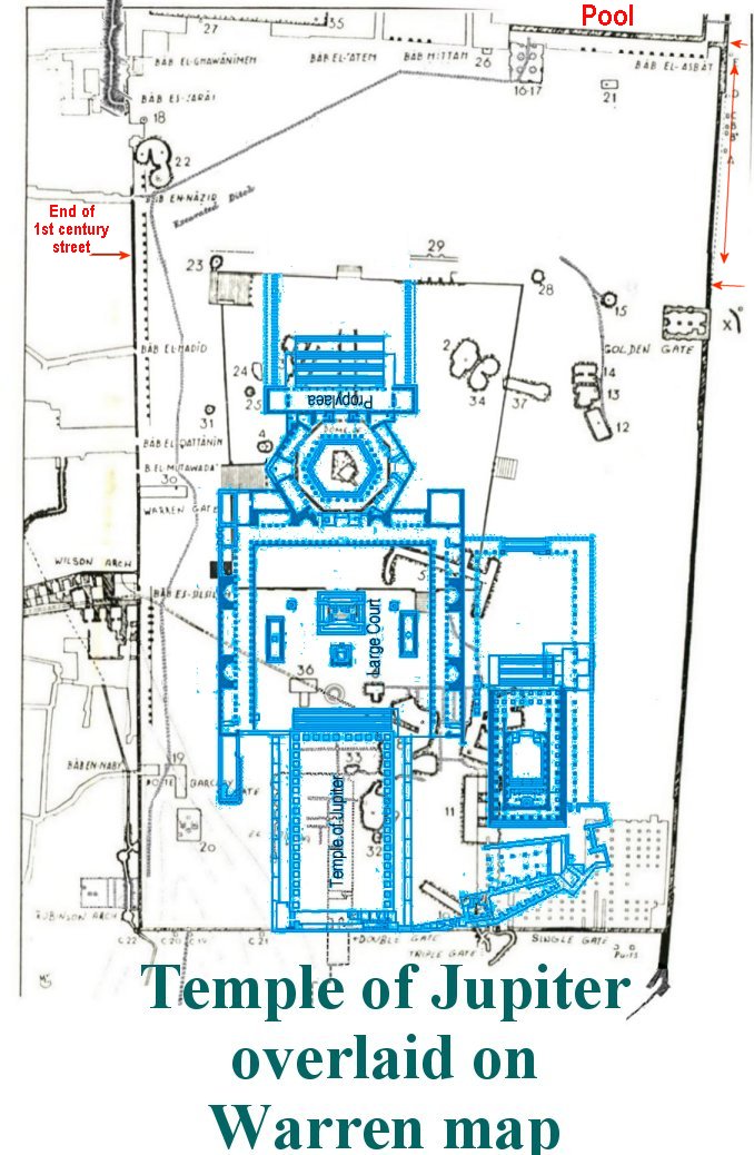
To accommodate such a huge Temple, similar to this one, Hadrian's builders would have needed to build up and increase the size of the mount at the southeast end. If this theory is correct then the best way to do this would be for Hadrian to build his south wall on the pre-existing platform at the top of the huge steps of the Ophel. The ruins of a partial wall, would have already existed and he need only rebuild it and extend it to the east.

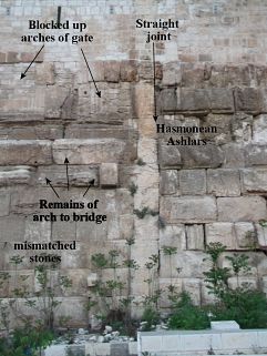
As you can see if he tried to take his enclosure any further to the south he would have to build even deeper into the Kidron Valley. To rebuild the outer wall of the former Temple of the Jews (white writing on the photo) would not work for that reason. This would mean that the Roman's are responsible for the size and shape of the Mount we see today. To build up the southeast corner to accommodate the Temple of Jupiter complex would require tearing down the bridge from the straight joint upward to the Portico of Solomon and then building the terraced vaults. It would require building a gate into this wall, which could then be reconnected with the bridge outside of the wall. The walled up arched openings can still be seen in the wall today near the straight joint.
A low wall believed to have been built possibly by Herod's grandson, extended all the way from triple gate down to meet up with the Nehemiah wall. The Red Heifer Bridge would have gone in between that wall and the Hasmonean wall.
This section of the east wall was not built by Herodian builders. And of course the southeast corner of Solomon's stable didn't exist when Nehemiah was rebuilding the city wall. At that time one would have been able to see the east wall of triple gate (Solomon's Porch) perched on the very edge of the steep hill.
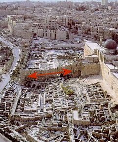
The Jewish cemetery is located directly across from the southern end of the Temple Mount. Jewish people of the time desired to be entombed directly across from the East Gate. In a direct line from this arch in the wall are the tombs of, what is called the Tomb of Zechariah. This tomb was actually built in the first century for the High Priest. It would have been below the Bridge. The Jewish Cemetery continues outward from there and one must wonder why the early Jews would be buried across from the south end of the mount, and not across from the supposed Golden Gate in the east wall of today, or across from the Dome of the Rock itself.

This is a digital illustration of what Herod’s Temple Mount might have looked like in 70 AD. Notice Triple gate (Solomon’s Portico) and the Red Heifer Bridge cross the steep valley to the Mt of Olives. Of course the Temple house was completely destroyed in 70 AD, long before the ground level of the Temple Mount was raised to its new level.

This is a digital illustration of what Herod’s Temple Mount might have looked like in 70 AD.

Of course the Temple house along with all the new buildings of Herod’s Temple were completely destroyed (not one stone upon another) in 70 AD, long before the ground level of the Temple Mount was raised to its new level.
Notice; Triple gate (Solomon’s Portico) and the Red Heifer Bridge across the steep valley to the Mt of Olives.
Return to Table of Content
Locating Solomon's Temple
THE OPHEL EXCAVATIONS
beyond the south wall
beyond the south wall
Chapter Five
The Ophel mound excavations began in 1968 soon after Israel got control of Jerusalem. At that time these ruins lay beneath tons of earth, as we can see by this photo taken in 1923.
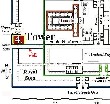
The Crusader building was built on the huge steps that lead up to Double Gate. Josephus described the Temple complex with many sets of steps leading up to the inner gates. Meaning the south section of the complex was terraced, with steps between the flat places.
These ancient steps reveal a lot about the Ophel Mound. They were originally cut into the bedrock, which protruded out of the earth. This is evidence of a gigantic rock mounding out of the ground at the top of this hill. I believe this rock to lead up to the threshing floor that King David bought and built the Altar to God on, and the place where Solomon built the Temple.

Josephus tells us that Fort Antonia was built on the highest hill, which overlooked the Temple and the Temple overlooked the City of David. This to me means there were two hills on this eastern ridge of Jerusalem. “King David purchased a threshing floor north of, and above, the City of David and on that foundation rock he built an altar to God. And before the altar his son built the House of God and in it he placed the Ark of the Covenant.”

Josephus describes the upper courts and the Inner wall. "This court was foursquare, and had a wall about it peculiar to itself; the height of its building, although it were on the outside forty cubits (58 ft), was hidden by the steps,
and on the inside that height was but twenty-five cubits (36 ft) for it being built over against a higher part of the hill with steps.(War of the Jews - BOOK 5, CH. 5)
and on the inside that height was but twenty-five cubits (36 ft) for it being built over against a higher part of the hill with steps.(War of the Jews - BOOK 5, CH. 5)

In the photo there appears to be 14 deep steps and 16 shallow steps. The shallow steps are for “stepping-up” to the next level. The large steps are where one would stop and pray before ascending to the next step, the same as it was for the steps in the women’s court that led up to the eastern inner gate.
Josephus describes the upper courts and the Inner wall.."This court was four-square, and had a wall about it peculiar to itself; the height of its buildings, although it were on the outside forty cubits, was hidden by the steps, and on the inside that height was but twenty-five cubits for it being built over against a higher part of the hill with steps. War of the Jews - BOOK 5, CH. 5)
So these appear to be the steps that led up to the upper Gate (Double Gate) of the inner wall, which encompassed the inner courts. At the top of the steps would then have been a terrace, called the chel ; (m. Kelim 1.8), a 15 foot wide walkway, which was bounded by the walls of the inner court. According to Josephus, there were fourteen steps leading up to the Chel or terrace.

I found even more proof in the ruins that the southern half of Solomon’s temple complex and Herod’s extended courts lay beyond the south wall. Herod’s wall foundations would most likely be thicker than Solomon’s older wall.

Earthquake
There is no way to know which earthquake in Israel's history caused the twisted mess in the midst of the Ophel hill ruins, but it seems as though it happened sometime before the Muslims built their new city wall through the center of the ruins.


The city wall was built right through the center of it. As near as I can tell, an angled wall on the other side of the city wall, is the other half of the gate.
Return to Table of Content
Locating Solomon's Temple
The Temple Mount Platform
Chapter Six
I thought that finding the water channels ending with a pool next to the Temple was probably the final thing to confirm this southern location for me, but to my delight, there was even more surprises to come.
When Herod the Great came into power over the Jews he desired to build a new Temple. The Porch of Herod's Temple would be 100 cubits wide, much wider then the old Temple. This required some adjustments to be made in the width of the original platform created by Solomon, it must also be widened. The platform included the Temple courts, the woman's court, and the portico on the east, called Solomon's porch. This platform was called the Way, or Street leading to the Holy of Holies.

There was a hel, or Chel (kel), a walkway, on both the south and north sides of the old temple platform.
In the Mishna it says that Herod set the foundation stone for the new Temple a little more to the north and to the west of the original temple. In doing this it actually caused the northern section of the Temple compound to become smaller.The only way the northern section could be made smaller is if the inner platform was increased in width towards the north by Herod, and a new Chel built on the north side. If my location for the Temple is correct then there should be evidence in the ruins on warren's map to confirm it.
Warren shows the northeast corner of the Triple gate halls, which would have been the Northeast corner of the old platform.

. 
Herod’s gate goes beyond the red dashed line of Solomon's platform. Which means Herod's increased the size of the platform. This also shows that even though the double halls were made after 70 AD there was still enough of the old ruins of Herod's gate left as to indicate an opening that could be dug through.
However, Solomon's gates would have been smaller and a closer together, along with the 10 cubit wide chel beyond his north inner gate. In this map we can see that Solomon's inner gates, and the north and south chel were within the perimeters of the old platform.
As you can see, Herod's north inner gate was extended beyond Solomon's platform.

Plus there must be a chel (walkway) on the north side of the platform, extending the width of the platform, what appears to be about 20 cubits at a regular Hebrew cubit. Notice that this decreases the northern section of the compound making it the smallest of the outer courts.
The Mishna says the southern section of the Temple compound had the most "open space", then the women's court, followed by the northern section, which had the least amount of open space.Remember that Herod the Great built the Temple and upper courts and gates, but the walls of his extended compound were added later by his grandson and great grandson and were not totally complete until 66 AD. This would mean that the old walls of Solomon's temple remained standing, for the protection of the new temple. So when it is said that, the northern section was decreased in size by Herod, they were speaking about the compound within Solomon's old walls, not Herod's extended compound.
Can I also show this through the ruins? I think so. Notice the eastern passage of double halls, the one that extends further north, ends as if going through a gate opening and then circles out.

Back when I first began this in Nov 2000 I really had no idea what I was doing. I was trying to fit the gates in using the layout similar to that of Ezekiel’s temple. I hadn't learned yet about the inner east gate being a double wide gate. Had never heard of the Mishna at that time. Plus information wasn't really "out there" on the web as it is today. My layout was very elementary, and was constantly changing as I gained new information. It was at that time that the Lord gave me a dream about the east inner gate. The dream was about an old, distinguished Hebrew woman and her young daughter. The time had come for them to receive their inheritance. Someone handed the daughter a beautiful box, kind of like an ornate jewelry box. What the old women inherited was inside the box, and the younger woman inherited the outside. They opened the box and the old women reached in with both hands to try and pull out what was hers. But it was part of the structure of the box itself. If she removed it the box would fall apart. They had to share the box, with the old and the new as one. I woke up and knew that it meant the east inner gate was a double gate, and began to draw it that way. A few months later I ran across the information on the net about the double gate.
I wondered why the Lord had brought this gate to my attention, in a dream, when he could have just helped me find the information on the net or library. But now I think I know why. That gate would end up being one of those "special things" that would help to prove this theory to me in a very unique way.
 .
.
In this diagram you can see by the red dashed line that Solomon's gate now sits directly across from the southern half of the double gate. With the double wide opening in this gate one would still be able to see into the Temple and view the curtain of the Holy of Holies with no problem.
Herod’s Temple Courts
Previous Chapter
Return to Table of Content
Locating Solomon's Temple
THE SOUTHWEST CORNER
Chapter Seven

The “Place of the Trumpeting” and the place above the Xystus reveal the real location of the Temple.
It seems that the location of the Temple has always been hidden in plain sight in the works of Josephus. Amazing!
We learn of the Place of the Trumpeting through Josephus as he describes the towers built by the Jewish Rebels who had taken over the city prior to its destruction. The rebels split into two groups and began warring against each other. One faction held the Temple and they built towers on the corners of the Temple compound to get a higher advantage for their arrows. One of those towers was built above the Xystus. So first we need to find out where that was.
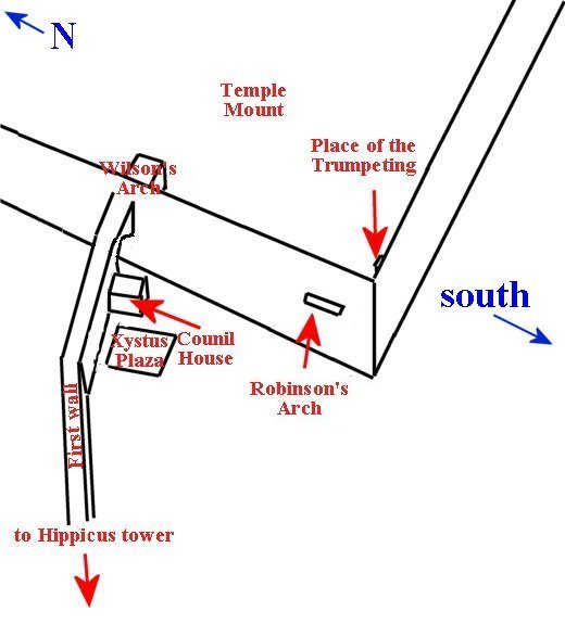
"Now that wall began on the north, at the tower called "Hippicus," and extended as far as the "Xistus," a place so called, and then, joining to the council-house, ended at the west cloister of the temple."
The Xystus was a plaza used for assembly, to hear public speeches made from the west wall of the Temple Mount.
The ruins of the Council House were discovered by Charles Warren in the 1860′s. It is located near the Western Wall and the bridge over Wilson’s Arch.
The Place of the Trumpeting was located at what is now thought to be the southwest corner of the Temple Mount.


At the base of the southwest corner the remains of “The Place of the Trumpeting” stone was found. It lay where it had landed after the destruction of the Temple.
Josephus tells the location of the towers that the rebels built.

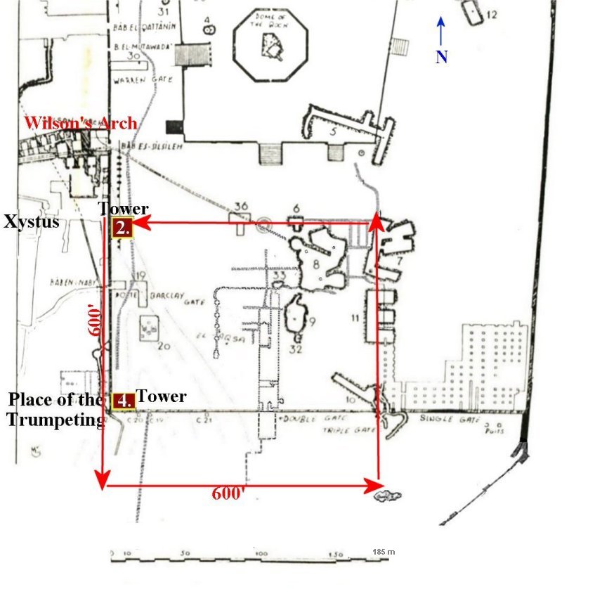
This graphic shows two of the towers. Numbers 2 and 4.
The first tower was built at the northeast corner of the Temple compound. The second on the corner of the Temple, across from the Xystus plaza. The third tower was built on the corner overlooking the City of David. Scholars trying to place these towers have great difficulty with the southern corner tower. Placing it at the southeast corner of the Mount, as it is today, red X on the next map, doesn’t work because it overlooks the Kidron Valley not the City. They end up placing it at the southwest corner. This places towers 3 and 4 in the same place!Josephus places the fourth tower at the corner of the “Place of the Trumpeting.”
Placing the towers on Warren’s map helps us to get our bearings.

It wasn’t until the Place of the Trumpeting stone was found that the puzzle could be put together, but I didn’t use the Trumpeting Place to show the location. Instead I used scripture, ancient survey maps, pictures of the Mount and Ophel, the writings of Josephus and the Jewish writings, such as the Mishna, etc. to discover this location.
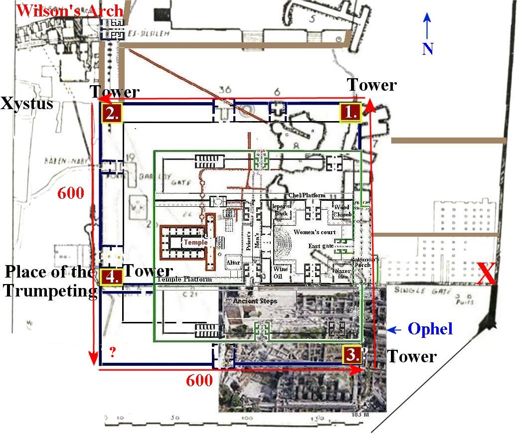
This graphic shows my Temple diagram laid over the map with the towers.
 ……
……
This is in no way the southwest corner Josephus was speaking of.
This is positive proof that the Temple was once located on the Temple Mount and not in the City of David or the Dome of the Rock.
South of this second wall, the western half of the Ophel mound, excavations revealed important data on the history of early Islamic Jerusalem. Four edifices, about 90 x 90 meters each, were unearthed and data to the Umayyad period (7th-8th centuries CE). These buildings are probably part of an official facility erected by the Caliph Al-Walid, and shedding new light on the status of Jerusalem during the Islamic period.
This stopped the western half of the Ophel from being excavated down to the level of that on the eastern side.

This whole area is now called the Ophel Archaeological Garden.

This is a photo of the Western section of the Ophel as it looks today. All work has stopped and any ruins from an earlier time will remain hidden.
Return to Table of Content
In 1838, an American historian, Edward Robinson discovered some stones projecting from the Western Wall, now called Robinson's Arch.


Jews have been returning to Jerusalem once a year, when permitted, since its destruction in 70 AD. I believe the location of the Temple was passed down, generation to generation, for at least a few hundred years after it's destruction.


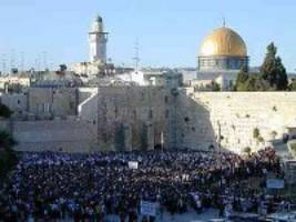 On the first day of Shavuot after the Six Day War, a quarter of a million Jews swarmed to the Wall.
I hope you have enjoyed this study. Thank you for visiting
Norma Robertson
Please feel free to contact me for comments or questions normar346@outlook.com
Previous Chapter
Return to Table of Content
Return to Home Page
Locating Solomon's Temple
THE WESTERN WALL
Chapter Eight
The Wailing Wall
The Wailing Wall on the western wall is located on the northwest section of Herod’s extended Temple complex.
Jews have been returning to Jerusalem once a year, when permitted, since its destruction in 70 AD. I believe the location of the Temple was passed down, generation to generation, for at least a few hundred years after it's destruction.
Under Turkish rule in the 16th century
During the second half of the sixteenth century, an Ottoman ruler finally gave the Jews full exclusive rights to the Kotel as a Jewish holy place of worship once a year on the 9th of Av. The area was buried under heaps of rubble, which the ruler removed. A prayer area was established along a 68 foot section of the wall with a width of around 10 feet, it was closed off by a wall running parallel to the western wall. The area was paved and this small enclosure became the sacred prayer site of the Jewish people, and a place to mourn the destruction of the Temple.
The Jewish mourners jammed into this small area in 1945.
In 1967 The Jewish army captured Jerusalem. After the Six Day War the buildings placed against the Kotel were removed and the entire area in front of it was cleared, leveled, and converted into a large paved open space. The area was partitioned off; one third is reserved for women and two thirds for men. The Kotel became a place of pilgrimage and prayer for Jews from all over the world.On the first day of Shavuot after the Six Day War, a quarter of a million Jews swarmed to the Wall.
Temple Mount History of the Dome of the Rock and Al-Aksa Mosque Enter The Greatest Lie ever told About Jerusalem
New! "Locating Solomon's Temple" now on Video!
click the playlist below
click the playlist below
 |
Norma Robertson
Please feel free to contact me for comments or questions normar346@outlook.com
Previous Chapter
Return to Table of Content
Return to Home Page
No comments:
Post a Comment